Introduction to Mt. Rinjani: Indonesia’s Second Highest Volcano
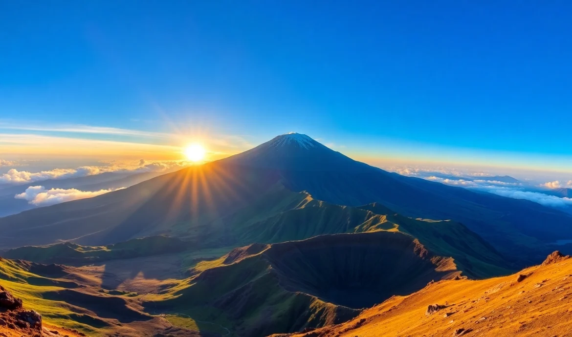
Nestled on the Indonesian island of Lombok, Mt. Rinjani is not just a towering natural marvel but also a profound symbol of Indonesia’s geological and cultural heritage. Standing at an impressive 3,726 meters (12,224 feet) above sea level, Rinjani is the second highest volcano in Indonesia and a prominent feature in the region’s landscape and ecosystem. Its majestic presence attracts thousands of adventurers, nature lovers, and spiritual seekers annually, eager to explore its challenging trails and witness its breathtaking vistas.
Beyond its sheer height, Mount Rinjani represents a vital part of local culture, history, and environmental conservation efforts. Its active volcanic status adds an element of raw natural power, reminding visitors of the volatile yet life-giving forces of nature. Whether you are a seasoned trekker or a curious traveler, understanding the significance of Rinjani provides a richer appreciation of this awe-inspiring mount and the experiences it offers.
Geographical Location and Significance
Mount Rinjani is situated within the Rinjani National Park (Taman Nasional Gunung Rinjani), which spans over 41,330 hectares on Lombok Island in West Nusa Tenggara. Geographically, it lies in the North Lombok Regency, forming the centerpiece of the island’s volcanic system. The volcano’s caldera, Barranco Valley, and the Segara Anak crater lake are emblematic features that contribute to its geological importance.
Strategically positioned in a seismically active zone, Rinjani plays a crucial role in Indonesia’s complex tectonic dynamics, caused by the convergence of the Indo-Australian and Eurasian plates. This positioning has resulted in its frequent eruptions, with the most notable recent activity recorded in 2015, which significantly impacted local communities and eco-systems.
The mountain is also a critical ecological zone, hosting diverse flora and fauna endemic to the Wallacea transition zone. Its ecosystems range from tropical rainforests at lower altitudes to alpine environments near the summit, making it an invaluable natural laboratory for biologists and environmentalists.
Basic Facts and Statistics
- Elevation: 3,726 meters (12,224 feet)
- Location: Lombok Island, West Nusa Tenggara, Indonesia
- Type: Stratovolcano and active volcano
- Last Eruption: Notably active; eruptions recorded in 2015 and historically several times over centuries
- Park Size: 41,330 hectares within Rinjani National Park
- Trail Distance: Approximately 27 kilometers from base to summit via popular routes
- Average Trekking Duration: 2-4 days, depending on route and fitness level
The mountain’s elevation makes it a challenging climb, with variable weather conditions and rugged terrain. Its prominence in the region makes it a dominant feature visible across Lombok and a key destination for adventure tourism.
Cultural and Environmental Importance
Rinjani holds deep spiritual significance for local Sasak, Lombok, and Balinese communities. The mountain is regarded as a sacred site, with traditions and rituals associated with its worship. Many local villages have longstanding cultural ties to the volcano, believing it to be a home of deities and spirits who influence the natural and spiritual world.
Environmentally, Rinjani’s biodiversity and ecological systems are vital. The park provides habitat for rare wildlife such as the Lombok monkey, various bird species, and unique plant communities. Conservation efforts focus on protecting these ecosystems from threats such as illegal logging, over-tourism, and the impact of volcanic activity.
Sustainable tourism initiatives aim to balance visitor access with environmental preservation, ensuring that future generations can continue to enjoy Rinjani’s natural and cultural riches.
Planning Your Mount Rinjani Trekking Adventure
Best Time to Climb and Weather Conditions
Optimal trekking periods are during the dry seasons, typically from May to October, when weather conditions are more predictable and rainfall is minimal. The months of June to September are especially popular, offering clear skies and stable temperatures. However, even during these months, mountain weather can be unpredictable, with sudden fog, rain, or altitude-related temperature drops.
It is crucial to monitor local weather forecasts and volcanic activity reports. The Rinjani volcanic alert system provides updates on eruption risks, which should always be considered before planning your trek. Planning during the dry season enhances safety and comfort, but always prepare for potential altitude sickness and sudden weather changes.
Necessary Permits and Preparation Tips
Trekking Rinjani requires specific permits, which can be organized through trusted tour operators or directly through the park authority. Permits help manage tourist numbers, fund conservation projects, and ensure safety protocols are followed. It’s advisable to start your permit application well in advance, especially during peak season.
Preparation also includes obtaining the right gear—warm and windproof clothing, sturdy hiking boots, waterproof essentials, and acclimatization medication if needed. Physical fitness is critical; engaging in cardio training, strength exercises, and altitude acclimatization hikes can significantly improve your experience.
Choosing Guided Tours and Hiring Guides
Given the mountain’s challenging terrain and unpredictable weather, hiring experienced guides and joining organized tours is highly recommended. Guides are knowledgeable about the routes, safety procedures, and local customs. Their presence not only enhances safety but also enriches the cultural experience through storytelling and local insights.
Tour packages typically include permits, porters, food, and accommodation arrangements. For example, guides usually charge around Rp. 350,000 per day, and porters about Rp. 300,000 daily, which helps support the local economy and ensures sustainable tourism.
Trail Routes and Hiking Experiences
Sembalun and Senaru Routes Overview
Rinjani offers two main trekking routes: Sembalun and Senaru. The Sembalun route, starting from Sembalun Lawang village, ascends on the eastern flank of the mountain. It is characterized by its expansive plains, volcanic landscape, and panoramic vistas, making it a favorite among experienced trekkers seeking varied terrain.
The Senaru route, originating from the northern side, traverses lush rainforests and waterfalls before reaching the crater rim. It offers a more shaded, scenic trek and is suited for those preferring a nature-centric journey with rich biodiversity.
Both routes converge at the summit, leading to the crater and the famous Segara Anak lake. Trekking these paths requires physical endurance and preparation but rewards hikers with extraordinary scenic highlights and a sense of accomplishment.
Difficulty Level and Preparation Requirements
The trek is considered challenging; it involves steep climbs, high altitude, and rugged terrain. The ascent from base to summit can take between 6 to 10 hours, contingent on fitness and weather. Altitude sickness is a concern above 2,500 meters, requiring acclimatization days and proper hydration.
Preparation should include physical stamina building, lessons on altitude acclimatization, and familiarity with rescue procedures. Experienced trekkers suggest practicing on similar terrains and taking gradual hikes to condition your body.
Proper gear is essential: layered clothing, trekking poles, high-energy snacks, and personal safety equipment. Adequate planning ensures safety and maximizes the enjoyment of the mountain’s diverse landscapes.
Highlights and Unique Landmarks
Key highlights along the trails include the lush rainforest zones, the iconic Mount Barujari (Inner Rim), the panoramic summit, and the spectacular Segara Anak caldera with its turquoise lake. The Lake Segara Anak, about 200 meters deep, is a mystical site where volcanic activity occasionally causes surface changes, and it offers stunning reflections of Rinjani’s crater walls.
Other landmarks include hot springs, waterfalls, and volcanic craters providing scenic and therapeutic experiences. The trail’s diversity—from tropical forests to lunar-like volcanic surfaces—makes it a truly immersive adventure.
Safety and Environmental Conservation
Risk Management and Eruption Alerts
Rinjani’s active volcanic nature necessitates vigilant safety measures. Trekkers should stay informed of eruption alerts issued by the Indonesian Volcano Monitoring Center and park authorities. During periods of increased activity, hikes may be postponed or canceled to protect visitors.
Carrying a personal emergency kit, communicating with guides about weather and volcanic status, and following established safety protocols are crucial for risk mitigation. Emergency evacuation plans are well coordinated but require prompt action in case of sudden eruptions.
Trekkers must respect signs and instructions on site, and local guides can provide real-time updates and safety recommendations.
Leave No Trace and Responsible Tourism
Protecting Rinjani’s fragile ecosystem is a collective responsibility. Practicing Leave No Trace principles—such as carrying out all waste, avoiding damaging flora, and staying on designated paths—helps preserve the park’s natural beauty.
Using eco-friendly products, supporting local communities through sustainable practices, and respecting cultural sites enhance the positive impact of tourism.
Emergency Contacts and Rescue Services
In case of emergencies, tourists should contact the local park ranger station or the Indonesian National Search and Rescue Agency (BASARNAS). Mobile networks are available in most parts of the park, but coverage may be limited at higher altitudes.
It’s advisable to register your trip with local authorities and carry local SIM cards for easier communication. Guides and tour operators typically have protocols for emergencies and evacuation.
Post-Trek Highlights and Local Culture
Local Villages and Cultural Experiences
Visiting nearby villages such as Sembalun and Senaru offers insights into the customs and daily life of Lombok’s indigenous communities. These villages are known for their traditional Sasak and Lombok cultures, including dance performances, handicrafts, and culinary experiences.
Engaging with local residents provides a deeper connection to the mountain, promoting respectful and sustainable tourism. Participating in cultural ceremonies or buying locally made souvenirs supports community livelihoods.
Wildlife and Flora of Rinjani National Park
The park harbors diverse flora, from tropical rainforests at lower elevations to unique alpine plants near the summit. The fauna includes endangered species such as the Lombok monkey (Macaca Lombokensis), various bird species like the Rinjani scops owl, and numerous insects and reptiles.
Conservation efforts focus on habitat preservation and eco-tourism, aiming to protect this biodiversity amidst increased visitation.
Additional Activities Around Lombok
Beyond Rinjani, Lombok offers a variety of attractions: pristine beaches like Pink Beach and Senggigi, water-based activities such as snorkeling and surfing, and exploring other islands like Gili Air, Gili Meno, and Gili Trawangan. Cultural festivals, traditional Sasak villages, and culinary tours add richness to any trip itinerary.
Combining mountain adventures with beach relaxation creates a holistic experience of Lombok’s natural and cultural diversity.